Aquatic habitat types
Habitat types along standing and flowing waters according to the Habitats Directive:
.jpg) " typeof=
“Hard oligo-mesotrophic waters with benthic vegetation of Chara spp.” (Natura 2000 Code 3140) can be recognized from the clean and clear water, and the submerged growth of stonewort communities which can even form a kind of submerse lawn. They only occur in water bodies that are mainly fed from ground water. The submerse lawns can be easily identified in clear water, e. g. in the Plittersdorfer Altrhein. Further information
" typeof=
“Hard oligo-mesotrophic waters with benthic vegetation of Chara spp.” (Natura 2000 Code 3140) can be recognized from the clean and clear water, and the submerged growth of stonewort communities which can even form a kind of submerse lawn. They only occur in water bodies that are mainly fed from ground water. The submerse lawns can be easily identified in clear water, e. g. in the Plittersdorfer Altrhein. Further information
 " typeof=
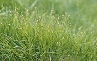
"Oligotrophic to mesotrophic base poor standing waters” (Code 3130) can be found in the Rhine floodplains along shores that fall dry in summer, e. g. at the Knielinger See and in the Kindelsgrund near Steinmauern. In this area within short time so-called dwarf-rush communities develop with low-growing plants such as spike-sedges. Further information
" typeof=
"Oligotrophic to mesotrophic base poor standing waters” (Code 3130) can be found in the Rhine floodplains along shores that fall dry in summer, e. g. at the Knielinger See and in the Kindelsgrund near Steinmauern. In this area within short time so-called dwarf-rush communities develop with low-growing plants such as spike-sedges. Further information
- " typeof= "Natural eutrophic lakes“ (Code 3150) are characterised by floating or submerged aquatic vegetation (e.g. duckweed and pondweed communities, water lilies): In a larger scale they are occurring in the oxbow lakes (e. g. Wintersdorfer Altrhein, Bärensee near Plittersdorf or Illinger Altrhein). In a small scale they can also occur in gravel or clay pits. Further information
 " typeof=
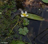
"Water courses with floating water vegetation” (Code 3260): This type of water vegetation floating in rivers and streams usually has narrow or finely slotted leaves in order to have little resistance to the current. Plants are species of the water crowfoot with white flowers, pondweed or water-starwort. The type is found in slowly flowing, large valley waters as well as in smaller, elongated streams with stronger current. Further information
" typeof=
"Water courses with floating water vegetation” (Code 3260): This type of water vegetation floating in rivers and streams usually has narrow or finely slotted leaves in order to have little resistance to the current. Plants are species of the water crowfoot with white flowers, pondweed or water-starwort. The type is found in slowly flowing, large valley waters as well as in smaller, elongated streams with stronger current. Further information
 " typeof=
"Rivers with muddy banks“ (Code 3270) are usually still flooded in spring and early summer. The occurring communities of the Bidention p.p. alliances and the Chenopodium rubri p.p. usually grow very fast and are very short-lived. Each year their location changes due to floods. In the management plan such muddy banks have mainly been mapped in the near-natural parts of Altrhein, e.g. at the Wintersdorfer, Plitterdorfer, and Illinger Altrhein. Further information
" typeof=
"Rivers with muddy banks“ (Code 3270) are usually still flooded in spring and early summer. The occurring communities of the Bidention p.p. alliances and the Chenopodium rubri p.p. usually grow very fast and are very short-lived. Each year their location changes due to floods. In the management plan such muddy banks have mainly been mapped in the near-natural parts of Altrhein, e.g. at the Wintersdorfer, Plitterdorfer, and Illinger Altrhein. Further information